UAV equipment will include the UAV itself, but will also include batteries. Depending on the UAV, there will be different battery sizes and these may come in various forms. It will be important to ensure that batteries are fully charged before the mission and a separate set of batteries will be particularly important if large areas are to be flown. Batteries will often need charging every day on longer visits and this must be prioritised for arrangements to flow smoothly.
Many sensors have software that will require updating. At times this can occur randomly, subject to the discretion of the provider. However, every effort to ensure updates have occurred should be taken to reduce time required in the field.
UAVs should be transported in heavy duty cases that do not allow soil, sand and water to enter and damage the equipment. These can be purchased along with your UAV to ensure that they are always stored correctly. Similar containers should be sourced to carefully store the sensor if a suitable container has not been provided with the sensor upon purchase.
Although any UAV and sensor (integrated or not) can be used for capturing data, it is recommended to use a survey-grade solution. RGB sensors that are not designed for surveys, may have an undetermined minimum time between captures and it is typically high (2 seconds per capture). This would hinder the ability to cover large areas within a timely period of consistent lighting.
Some recommended options include the DJI M300 with a Zenmuse P1 , or a Mavic 3 Enterprise.
Additional equipment for weed detection missions will include:
- A gazebo that can be secured to the ground – this offers sun and rain protection and if purchased with walls, can offer significant wind protection also. This is highly important for operator safety in harsh conditions.
- Chair/s for operators – this can be useful if wind picks up and you need to wait whilst software updates, or if you need to transfer data to a laptop in the field to make room for more data!
- One to two small folding tables that can be used to store the UAV and the sensor/s above the ground during rest periods or inclement weather that may arise whilst at the site. Having the equipment off the ground can prevent the wind blowing sand or soil material into areas that may cause damage
- Landing mat – heavy duty rubber matting can be purchased from hardware stores and these are used to enable the UAV to take off and land safely on various terrain.
- Inverter and charging stations, power cords– when taking imagery, there will be a large volume of information stored on SD cards in the sensor. It will be important practice, particularly for larger sites, to have the capacity to move data from SD cards in the sensor to a folder on a laptop for later processing. An inverter can provide the power from vehicles at remote locations so that this can occur most efficiently.
- SD cards – these will need to be the right size for the sensor so as to store the imagery that is taken during each flight. You will need a number of these and a container to store them safely.
- Wi-Fi capacity preferred– this will be either via a mobile Wi-Fi purchased at a local internet provider or using a base station and linking to an NTRIP corrections service provider such as CORSNET. Alternatively, post processing would be necessary to generate accurate GPS position of species (RTK or PPK) - see section on “Georeferencing”.
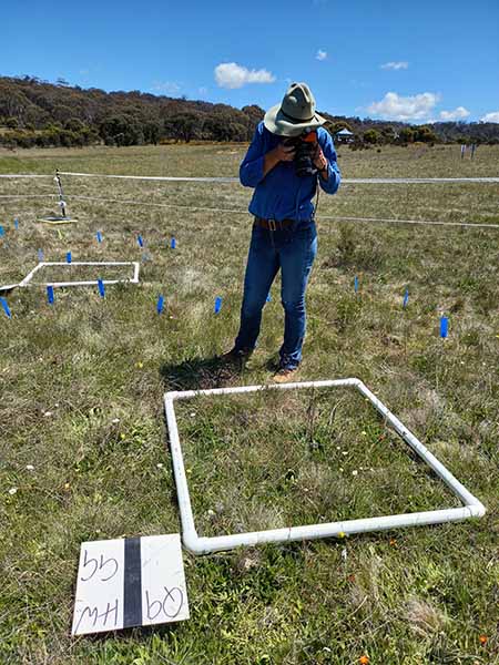
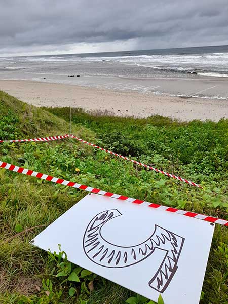
- A minimum of ten quadrats that can be placed across the flight zone and used as known areas where target species and other species are located (more on this in the section on Ground Truthing) – these need to be made to specifications based on the weed species and terrain. Smaller plants such as hawkweed or individual African Lovegrass plants would be suitable for quadrats made from 40 mm PVC pipe, with 90 degree elbows (see Fig 1 below). Other larger species, such as bitou bush, or large sprawling infestations of African lovegrass will be more suited to coloured tape and pegs placed in the corners to make larger quadrats. Tape needs to be wide and brightly coloured and pegs can be wood or fiberglass, and could also be made from electric fencing posts. They need to be light, easily moveable and be clearly visible in the ground (see Fig 2 below).
- Ground control Points – these are used to provide GPS references of the area for the imagery, allowing imagery to be stitched together for later processing. More detail on these in the section on “Ground Truthing”.
- Data sheets – these will be used to record flight data and enable the recording of the vegetation assessments in the quadrats.
- PPE, food and water – important for operator safety during longer days at remote locations.

Fig. 1. PVC 1 m x1 m plastic quadrat – suitable for small species. Source: Wendy Menz (NSW DPE)

Fig. 2: Brightly coloured tape and fibreglass peg quadrat – suitable for species with large or bushy growth habit. Source: Dr Jane Kelly (CSU)

